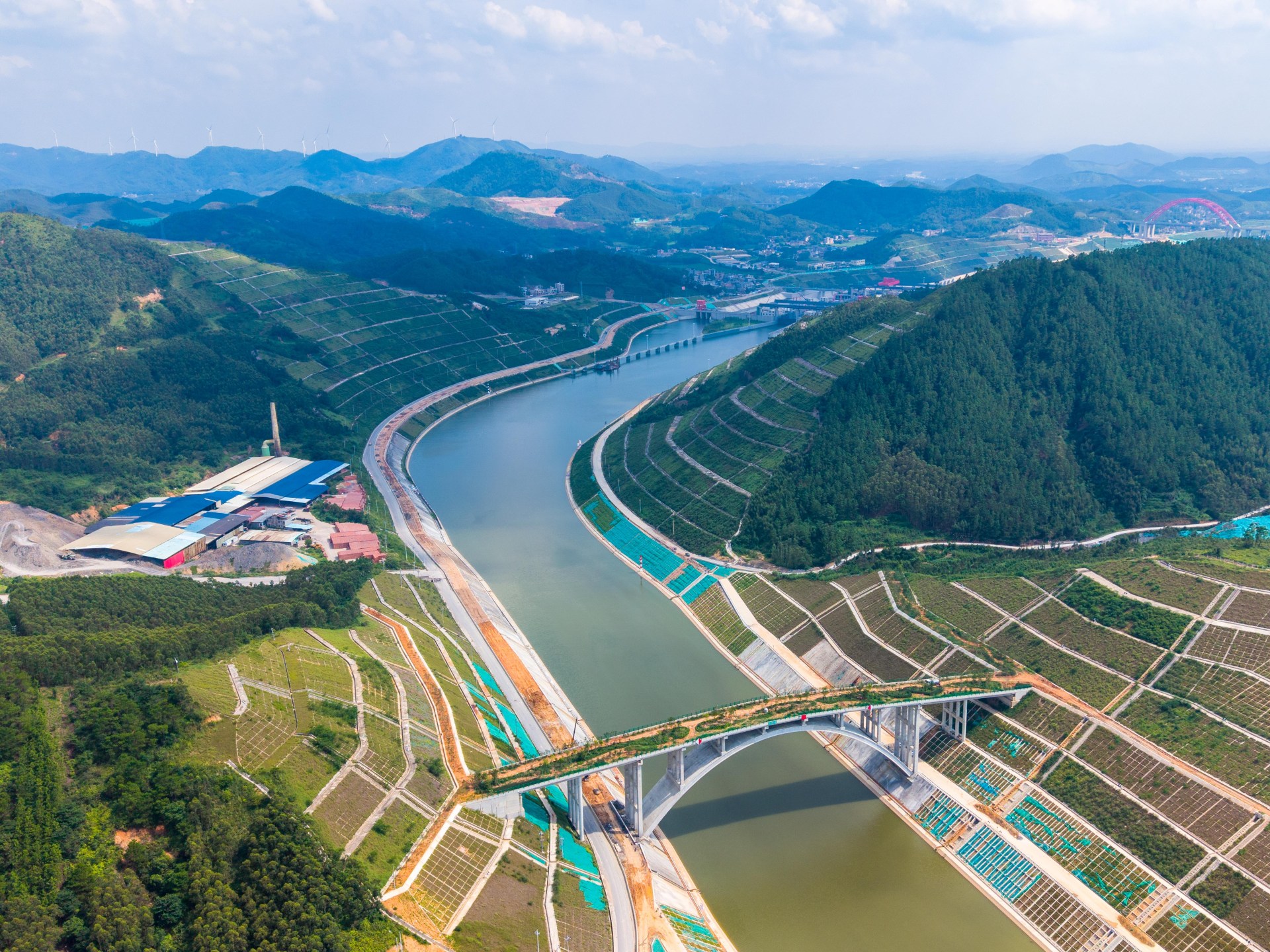
Beijing, China – China will open its first modern river-sea canal for shipping on Wednesday, a project that aims to dramatically reduce shipping distances between the country’s hinterland and Southeast Asia, a region that serves as a critical trading partner. The Pinglu Channel is located entirely in Guangxi, the region in the far south of China that borders Vietnam and overlooks the South China Sea. This 134-kilometer (83-mile) waterway links the Xijiang River with the Beibu Gulf, the northwestern arm of the Gulf of Tonkin stretching between southern China and northern Vietnam. It provides vast areas of southwestern China, including provinces such as Yunnan and Guizhou, a shorter route to the sea and Asian markets. Pinglu, the first such canal built by communist China, is part of the New International Land-Sea Trade Corridor: a project involving China’s southern provinces aimed at linking areas of western and southwestern China with Southeast Asian countries and global markets. The land-sea trade corridor is itself part of Chinese President Xi Jinping’s Belt and Road Initiative, a network of roads, ports and railways that seek to connect China with Europe and Africa. Aerial view of the Qingnian ship lock of the 135-kilometer Pinglu Canal under construction in Qinzhou, south China’s Guangxi Zhuang Autonomous Region, Saturday, August 16, 2025 [Peng Huan/ Feature China/Future Publishing via Getty Images]The real win: distance and cost savings According to local authorities in Guangxi, the canal will shorten the shipping distance between inland areas of southwestern China and Southeast Asian countries by about 560 kilometers (350 miles) and reduce logistics costs by 18 to 30 percent. Estimates by Zhang Zhiwen, deputy secretary-general of the Guangxi government, indicate that transportation costs alone will be reduced by more than 5 billion yuan a year, or about $700 million. Its president, Lu Xinning, describes these benefits as “tangible gains” that reduce operating costs and boost domestic and foreign trade. The canal will allow the passage of ships with a capacity of 5,000 tons. Its estimated cost is about 72.7 billion yuan, equivalent to about 10.8 billion dollars. This means that cities and industrial zones far from the coast in southwestern China will move closer to maritime trade routes. The new trade corridor does not only serve Guangxi; It is connected to a wider network that extends to Chongqing in southwest China, Chengdu in Sichuan province, Guizhou and Yunnan, before goods reach ports in the Beibu Gulf and from there to overseas markets. These changes come at a time when trade between China and Southeast Asia is growing rapidly. According to the General Administration of Customs of China, bilateral trade in the first half of 2026 reached about 4.34 trillion yuan, or about $640 billion, a year-on-year increase of 18.2 percent. At the southern end of the canal, container handling capacity at the Beibu Gulf port increased from 2.28 million TEU in 2017 to 10.06 million TEU in 2025, with a shipping network covering major Southeast Asian countries. Ports.A Chinese national flag flies against high-rise residential buildings in Wushan county, southwest China’s Chongqing municipality, Wednesday, May 21, 2025. Chongqing is one of the main inland regions that the canal will connect to Southeast Asia. [Andy Wong/ AP Photo]From waterway to industrial hub, Guangxi is also working to build what it calls the “Pinglu Canal Economic Belt,” aiming to attract industries and spread them along the new corridor, while connecting them to ports, transportation networks and supply chains. Target sectors include non-ferrous metals and critical minerals, modern green chemicals, as well as artificial intelligence and information technology. Industrial zones are also being developed near ports, reducing the distance between production sites and shipping centers. The process of organizing and directing shipping sources has already begun to generate new business activity. A train loaded with sodium bisulfate recently arrived from Chongqing, the main industrial and transportation center in southwest China, to the port of Nanning, capital of Guangxi province. After the opening of the canal, direct commercial voyages to the port of Can Tho in southern Vietnam are scheduled to begin. On the operational front, Guangxi has adopted a tiered transit fare system that gives operators a grace period before imposing nominal charges. Until December 31, 2026, commercial ships will pass through the three gates along the canal completely free of charge. Starting January 1, 2027, a fee of one yuan, approximately $0.14, will be charged for each ton of a ship’s capacity each time it passes through these gates. This trial tariff will remain in effect until September 2031. River ships can sail directly to Qinzhou Seaport berths without needing to transfer their cargo to other ships, allowing for a seamless transition from river to sea. Many people in Hengzhou, Guangxi, seen here flooded after a cyclone in July 2026, have been displaced by canal construction. [China Daily via Reuters]Resettlement: another side of the canal projectThe construction of a canal of this scale would not have been possible without addressing a sensitive human dimension: the relocation of thousands of families from their lands. According to official sources, 2,764 households consisting of 11,228 people in four counties and county-level cities in Guangxi participated in the resettlement process. In Hengzhou alone, evacuation agreements were signed for 368 homes, which were completely demolished on a total area of 84,200 square meters (906,321 square feet), with 1,221 people temporarily resettled. The process was not managed solely through financial compensation. Instead, 21 different housing models were designed according to the residents’ customs: the orientation of reception rooms, crop drying areas, bird enclosures and agricultural chemical warehouses. In Shaping, the largest town in the resettlement project, residents received four-story houses covering 420 square meters (4,520 square feet), some with commercial storefronts facing the street. Still, there is a sense of loss among many, albeit tempered by hope for the future. In Xinfu, where Fenghuangping Village once stood, a resident who was forced to leave said: “There is no longer a village called Fenghuangping, but with the Pinglu Canal, tomorrow will be better.” Some families moved seven-century-old trees to their new home site, including a 217-year-old camphor tree. The resettlement process took place in 39 days, but was tied to promises of construction site employment and vocational training for residents of the relocated areas. Ships in the Iranian port city of Bandar Abbas on September 12, 2026 [Fatemeh Bahrami/Anadolu via Getty Images]How geography is reshaping trade security Straits and maritime corridors have long been the arteries of power in the global economy, but they are also among its most sensitive points of weakness. The Hormuz crisis embodies this paradox: the passage through which about a fifth of the world’s oil supplies flow can, when threatened, become a factor that paralyzes trade and redesigns its routes. Against that backdrop, countries around the world are trying to develop alternative routes and supply chains: pipelines, storage facilities and transportation corridors that reduce nations’ dependence on just one or two routes. The Pinglu Canal is China’s latest effort to do just that: build an alternative, shorter and faster route to a critical market.