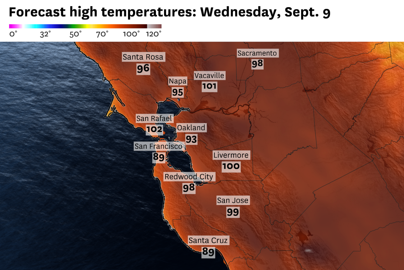
Wednesday is forecast to rival the hottest day so far this year in San Francisco, Oakland and San Jose, with temperatures between 80 and 100 degrees across the Bay Area, and Pacific beaches even in the 70s to mid-80s. Baron/Lynx In a major twist in the forecast, a three-day heat wave is now expected to hit the Bay Area Tuesday through Thursday, triggering a heat advisory for the region which will begin at 10 am on Wednesday and will last until 10 pm on Thursday. San Francisco, Oakland and San Jose could see their highest temperatures so far this year, with the National Weather Service forecasting temperatures 10 to 20 degrees warmer than normal in some places. Exceptionally warm nights will make the heat wave much more extreme across the region. Previous forecasts indicated that the remnants of Hurricane Marie would keep temperatures cool and bring rain chances to Northern California, but that changed. Marie’s persistent circulation is now expected to be well offshore, far enough to disrupt the typical cooling sea breeze in San Francisco, but close enough to send tropical clouds over the Bay Area. That combination of light winds and high-altitude clouds will combine for hot days and warm nights across the region. The National Weather Service said a heat advisory will likely be necessary on Wednesday and Thursday. Article continues below this advertisement. Here’s the forecast for this week: Warm temperatures begin Tuesday. Temperatures are expected to rise on Tuesday due to a confusing atmospheric pattern. High pressure will build over the surface of northern Nevada as a cool, dense air mass persists due to the weekend cold. At the same time, the remaining low pressure from Hurricane Marie will draw air toward it and temporarily stop the northerly winds that dominate along the California coast during the summer and early fall. Former Hurricane Marie is expected to alter atmospheric pressure and wind patterns along the California coast. San Francisco will warm significantly as the cooling sea breeze ceases. Baron/Lynx This combination of high pressure inland and low pressure off the coast will slow or completely shut down the cooling ocean breeze across the San Francisco Bay. Without this natural air conditioning, downtown San Francisco should warm into the 80s, San Jose should reach the mid-90s, and the mid-90s will prevail in the inner East Bay and North Bay. Article continues below this advertisement. Tropical clouds, associated with the hurricane’s persistent high-altitude winds, will move over the Bay Area Tuesday night. These clouds will provide a blanket overnight and limit lows to the 60s and 70s across the region. Low temperatures will remain in the 60s and 70s across the Bay Area Tuesday night, about 10 degrees above normal. Baron/Lynx The hottest day so far this year is possible on Wednesday. Without a sea breeze, Wednesday has a chance of being the hottest day so far this year in San Francisco, Oakland and San Jose. Those numbers to beat are 90, 93 and 98, respectively. Wednesday’s highs are expected to be around those marks in each city. Article continues below this advertisement Triple-digit heat is possible anywhere away from the immediate coast. Even the Highway 101 and Interstate 280 corridor along the Peninsula could see temperatures between 90 and 100 degrees. Wednesday night will be brutally hot for people without air conditioning. Lingering moisture high in the atmosphere will produce a greenhouse effect and trap heat overnight, even without clouds in the area. Low temperatures may not drop below 70 degrees in the inland valleys of the East Bay and South Bay. A very weak sea breeze may briefly reduce temperatures to the 60s in downtown San Francisco and Oakland in the late afternoon, but heat radiating from buildings and roads will warm cities again once the winds die down after sunset. What remains of former Hurricane Marie will likely be too far from California to significantly affect Thursday’s weather. Northwest winds are expected to resume in the afternoon, but not before another hot morning in San Francisco and Oakland, where temperatures may reach 80 degrees before noon. The breeze will be delayed in the inland valleys. San Jose is still likely to reach 90 degrees, and triple-digit temperatures are again possible in parts of the North Bay and East Bay. Article continues below this advertisement. Natural air conditioning will resume across the region on Thursday evening. Low temperatures are forecast to fall into the 50s and 60s across most of the Bay Area. Elevations above 1,000 feet may remain in the 70s for another night, but a deepening marine layer over the weekend should also cool the mountains. High temperatures are expected to return near September averages by the weekend, in the 60s on the coast, 70s along the bay coast and 80s inland.