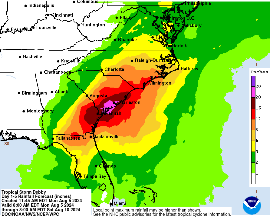
Rainfall Forecast
Tropical Storm Debby, currently churning in the Gulf of Mexico, is rapidly intensifying and poses a significant threat to the southeastern United States. As of the latest advisory, Debby has sustained winds of 60 mph with gusts up to 75 mph and is moving north-northeast at 8 mph. The National Hurricane Center (NHC) has issued multiple warnings and watches, with a Hurricane Watch in effect for parts of Florida’s northern Gulf Coast (Track the Tropics).
Debby is expected to make landfall in the Big Bend area of Florida, potentially crossing into Georgia and the Carolinas. The storm’s path indicates two possible scenarios: it could weaken over land, resulting in significant rainfall and localized flooding, or it could re-enter the Atlantic Ocean, gaining strength and posing further threats to the Mid-Atlantic region (Track the Tropics).
The storm’s projected rainfall is substantial, with central and northern Florida, as well as central and northeast North Carolina, expecting 6 to 12 inches of rain, with some areas potentially seeing up to 18 inches. Southeast Georgia and the coastal plains of South Carolina could experience even more severe rainfall, with totals ranging from 10 to 20 inches and isolated areas receiving up to 30 inches. This deluge raises concerns about catastrophic flooding and significant river overflow (Track the Tropics).
Debby’s wind field extends outward, with tropical-storm-force winds reaching up to 120 miles from the center in some quadrants. The combination of high winds and rain is likely to cause extensive damage to infrastructure, downed trees, and power outages. The storm surge, particularly along the Gulf Coast and later the Southeast U.S. coast, could lead to life-threatening conditions. Swells generated by Debby will affect the Gulf coast through the night and are expected to reach the Southeast coast, exacerbating the risk of dangerous rip currents and surf (Track the Tropics).
The areas under threat from Debby are densely populated, with millions potentially impacted. Florida, Georgia, and the Carolinas are urging residents to prepare for power outages, evacuations, and possible long-term disruptions. Shelters are being prepared, and emergency services are on high alert to respond to the storm’s aftermath (Track the Tropics).
In central and northern Florida, the immediate threat includes possible tornadoes as Debby makes landfall. These areas are also preparing for significant urban and flash flooding, which can cause severe disruption to transportation and daily life. Schools and businesses in the storm’s path have been advised to close, and residents are urged to secure their homes and properties (Track the Tropics).
Debby’s trajectory and intensity bring back memories of past storms that have caused widespread damage in similar regions. Authorities are warning that the combination of high winds, heavy rainfall, and storm surge makes this a particularly dangerous storm, even if it doesn’t reach hurricane strength. The NHC emphasizes the need for vigilance and preparedness, urging residents to heed evacuation orders and stay informed through reliable sources (Track the Tropics).
The next full advisory from the NHC is scheduled for 5 PM EDT, and continuous updates will be provided as the storm progresses. Residents in the potentially affected areas should stay tuned to local news and weather updates to ensure they have the most current information and can take appropriate actions to protect themselves and their families (Track the Tropics).
For more detailed and updated information on Tropical Storm Debby, visit the The News 24.